Location Data Guide: What is it, use cases & examples
What is Location Data?
Location data refers to information that identifies the geographical position of a device or individual. This data is typically obtained through various technologies such as GPS, Wi-Fi, and cell towers. It includes details such as latitude, longitude, altitude, and sometimes even the speed and direction of movement. Location data is widely used in applications and services, ranging from navigation and mapping to location-based recommendations and targeted advertising. While it provides valuable insights for personalized user experiences, it also raises privacy concerns, as the collection and misuse of location data can potentially compromise individuals’ privacy and security.

Best Location Data Databases & Datasets
Here is Datarade's curated selection of top Location Data. These trusted databases and datasets offer high-quality, up-to-date information.

Factori Raw Location Data | Global mobile location data (1 year history)
Irys | Location Data Solutions | Worldwide Global | Real-Time & Historical Mobile Data & Connected Device Location Data
Area Visitors -- analyze global foot traffic trends for geographic areas via API or batch data delivery
Redmob: Mobility Data | Mobile Location Data | Africa | (GPS Location Data)
Unacast Location Data - Global Mobile Location Data - Current & Historical
Factori Global Location Intelligence Data| Geospatial:Foot Print:Places Data|
Irys | Location Data Insights | Africa | Real-Time & Historical Mobile Location Data
Location Data | Store / Business location Data | Global Coverage | 400M+ Contacts | (Verified E-mail, Direct Dails) | Decision Makers 20+ Attributes |
Location Data | Global Store Location Data on 51M+ POI | SafeGraph Places
The Data Appeal | GIS Data | Places Data | Store Location Data | Business Location Data | 200 Million + POI Data Mapped | API, Dataset
Top Location Data Providers & Companies
Datarade considers factors such as data accuracy, coverage, granularity, update frequency, data sources, data quality, compliance with privacy regulations, data enrichment capabilities, API availability, and pricing models when recommending location data vendors and sources.
-
 FactoriBased in USA
 Factori is a flexible and adaptable data provider. We help you make smarter decisions and build better solutions based on real world location data.
 -
 IrysBased in USA
 Datasets built for decision-makers. Validate your intuitions and gain insight into the behavior of consumers, cities, and marketplaces.
 -
 Gravy Analytics by UnacastBased in USA
 Gravy Analytics and Unacast Merge to Become Leader in Location Data and Insights! Together, the new company’s strength is in its diversified client base and ...
 -
 RedmobBased in Singapore
 We possess a profound understanding of the impact of big data and research in crafting robust, unique data segments tailored specifically for mobility analyt...
 -
 SafeGraphBased in USA
 SafeGraph is a data company that builds datasets on the physical world for teams at ESRI, Microsoft, Verizon, and Mapbox. Our high-precision Places dataset c...
Popular Use Cases
Location Data plays a pivotal role in various business applications, offering valuable insights and opportunities across industries.
Location Data Explained
The past two years have proven that spatial intelligence is crucial for business, government, and urban development. Reliance on location data for strategy and analytics is only set to grow in 2024. We’ve gathered the latest updates and trends on the future of location data - its sources, market size, and increasing power as a resource for good.
Why Location Data matters
Location data is one of the most important external data categories available. 80% of external data collected in today’s data ecosystem has a location component. This is largely because it’s so versatile - it has an endless number of use cases and market applications.
Understanding the physical world and how people are moving around it provides the core analytics for a plethora of industries and organizations. International corporations, emerging startups, as well as governments and NGOs - all are investing in location data to shape their strategies around movement. And by ‘movement’, we don’t just mean how the individual gets from A to B. Location datasets also cover the flow of transport and goods through the supply chain, across seas, airspaces and territories. These data points enable users to monitor mobility trends and map POIs (points of interest).
Key Points:
- The global market for location intelligence set to reach $29.90bn by 2026, with a predicted CAGR of 16.1% for 2022-2027
- Increased connection to 5G network driving up supply of real-time mobility insights as number of devices connected to 5G forecast to hit 1.34 billion in 2023
- Location intelligence is growing more versatile, driving success in diverse use cases: “We’re just an ingredient in any one solution. It’s like selling high-quality butter to pastry chefs. The end consumer of the croissant may not even know that there’s butter in the pastry. But the chef knows how important the ingredient is,” - Auren Hoffmann, CEO, Safegraph, leading geospatial DaaS company.
Examples - Why location data matters
Here’s just a few examples of how location information is underpinning decision-making in commerce, urban planning, and government:
Location Data for commerce: from price-pointing to geo-marketing
Location data enables companies to shape effective strategies throughout the sales cycle. Retailers rely on location data to identify where to build brick-and-mortar stores, taking local demand, footfall, and competition into consideration. Analyzing average consumer spend and affluence metrics in a given area, businesses can optimize their price points from location to location.
Airbnb deploy pricing algorithms which determine rental property prices based on local amenities and transport connections. And they’re not alone: some of the most successful online and app-based retail and hospitality startups are utilizing location data to drive ROI.
US food delivery service DoorDash built its product around customer hotspots, restaurant availability and driver routes in a targeted location. It’s a strategy which has earnt DoorDash over 56% of the market share.
Location-based marketing is becoming increasingly innovative. With location data, digital marketers can build customer audiences and segments according to real-life visits, as opposed to digital footprints alone. Geofencing and geo-triggered advertising allow marketers to time the delivery of ads and pop-ups around the consumer’s physical location and POIs. Combining offline and online behavior, location data means marketers can deliver a more relevant and cohesive brand experience.
Location Data for urban planning: making cities smarter
The number of smart cities globally will increase in 2023. Last year, Germany invested €790 million in improving quality of urban life. Smart cities use real-time mobility insights to shape urban infrastructure around the movements of city-dwellers via connected device networks. This intelligence allows planners to produce digital landscapes which are updated according to mobility trends.
Aside from smart cities, developers are building more accurate population density models based on GIS insights. Census records only provide data every decade; economic reports tend to be published once a quarter. Mobile and satellite location data overcomes this information lag. As a result, companies in the urban development, civil engineering and real estate sectors can make informed geospatial decisions based on ultra-timely information.
Location Data for government: optimizing crisis response
COVID-19 demonstrating the importance of location intelligence. Understanding foot traffic patterns underpinned policy-making, with location data provider SafeGraph sharing their data with the CDC to improve the governmental response to the public health crisis. Location data is also helping fight the climate crisis. Scientists rely on ultra-precise satellite imagery to track the movements of polar and monitor changes in spatial conditions, from expanses of rainforest to individual crop fields. The same satellite data is also used to prevent humanitarian crises by predicting natural disasters.
So location data is a tool with many uses. It’s only going to become more versatile, as the information in a location dataset becomes more varied. Let’s have a look at the location data attributes of today, and the new attributes being added to datasets.
Main Attributes of Geolocation Data Explained
Of course, the basic attribute of any location dataset is geospatial information. This is given in various units: lat/long address, visual heat maps mapping foot traffic, or IDs, placekeys and geocodes specific to the provider. Other attributes include metadata about a location , such the building height, local amenities, and consumer footfall in the surrounding polygon
Across the external data industry, location data services are becoming increasingly tailored to each data client’s needs. Though unstructured, generalized mobility datasets are still available and valuable to many clients, most data providers now offer custom location intelligence, with attributes of the client’s choosing. For example, vendors will compile data points according to a specific geography, whether a country or ZIP code. This saves time in data cleaning and analysis.
To enable clients to unlock value from location data, providers enrich it with other data points. Connecting location intelligence to demographic data points, for example, enables marketers to build more detailed customer profiles. Similarly, location data providers are connecting sources of mobility intelligence and offering them as one unified service. Spatial intelligence businesses are enabling their clients to access insights into car movements, flight patterns, and consumer mobility via one integrated data platform.
On top of this, location data is becoming more accurate, granular, and faster to access. This is largely because 5G networks detect device movements spooner and to a greater degree of precision. The signals produced by 5G-enabled devices correlate to movement between individual POIs from locations as small as an ATM or bus stop.
Lastly, location data is becoming digestible to the everyman, not just the data scientist. It’s crucial that location data can be put to use by all organizations without the need for resource-intensive data analysis teams. To democratize the value of location data, providers are unifying attributes of mobility data sets, and ensuring that datasets are ready to be integrated into the client’s existing technologies. This way, startups can reap the rewards of location data just as readily as companies with big data budgets.
On this note, let’s have a look at trends in the location data market: who’s buying, who’s selling, and how much location data costs.
The market for Location Data in 2024: supply, demand, pricing
As ever, tech companies are leading the pack when it comes to driving demand for data and AI. The same is the case for location data. Nonetheless, others are catching up. CPG companies like Burger King are harnessing location data for location-based marketing, including a geofencing campaign against rival McDonald’s in 2018.
In terms of supply, startup provider companies are leveling the playing field. High-quality, privacy-assured location data is becoming available open source for the benefit of all. External location datasets are available to buy at more affordable prices. This is thanks to the rise of the data marketplace, which has seen companies join data commerce platforms to turn their proprietary location data into a viable revenue stream.
To understand location data supply, it’s worth taking a deeper look at today’s location data providers to find out the ones you need to know about.
The Location Data-as-a-Service Companies to have on your radar
There are several big players in the location analytics market, including Microsoft Corporation, Google LLC, IBM Corporation, SAP SE, Cisco Systems, and Hexagon AB. These companies have sophisticated data collection and storage technologies, so have a wealth of location intelligence.
However, most suppliers of location data are younger companies, found on data commerce platforms and data marketplaces, like Datarade’s Data Commerce Cloud. Here, you’ll find mobility data leaders like Lifesight, SafeGraph, and Geolytica. These data vendors specialize in delivering location intelligence at scale, on-demand, and tailored to a specific use case.
Many location datasets and APIs are instantly purchasable, with datasets varying in cost according to data coverage and recency. Providers with products available to buy instantly and effortlessly are disrupting the location data ecosphere, making location data commerce more transparent and accessible to all.
If you’re still with us, it’s time to get a bit more technical as we look at methods of location data sources and collection - the traditional, and the up-and-coming.
How does Location Data collection work?
There are many different ways to collect location data. Its sources are widespread: locations can be calculated with the help of objects like vehicle fleets, wearable devices, shipping cargo, among many others. However, in this article, we’ll be looking primarily at mobile or cell phone location data. For marketers aiming to target customers’ locations more precisely, in 2023 they are most likely to rely on cell phone location data, due to the ever-growing usage of smartphones. So we first need to understand the device which is responsible for generating most location data today – your smartphone.
What are these signals and where do they come from?
Collecting mobile phone location data requires two components: a signal and a receiver. Although we often think of smartphones as transmitting signals, in this context this isn’t the case. They’re actually receiving them, and as such, are often called receivers. The signals can be transmitted by the following:
-
GPS Satellites – GPS (global positioning system) works using the 31 GPS satellites which orbit the Earth. Satellite data is another branch of geospatial data. Each satellite transmits signals which are received by a device, and the device’s location is determined by calculating how long the satellite’s signal took to reach it. GPS can calculate outdoor locations accurately to within a 4.9 m radius when the sky is clear. Location accuracy is reduced indoors, underground, and in places with tall buildings and trees. However, for the most part, GPS location suppliers provide a reliable understanding of device location that is broadly the same for all mobile users.
-
WiFi Routers – WiFi performs significantly more accurately indoors than GPS. It determines the location of a device, like a cell phone or laptop, by calculating the distance between the device and an ‘access point’, which is what allows devices to connect to a local WiFi network. The data generated is granular, accurate between 10-100 metres, and is especially useful when GPS and cell tower signals aren’t available. However, it’s common for users to register to public WiFi with fake email accounts, so the device may not always represent the user.
-
Beacons – A beacon is a piece of hardware which transmits information via a Bluetooth signal, which is picked up in the device by a software development kit (or SDK – a piece of software built into an app. We’ll look at SDKs in more detail shortly). Beacons can calculate location data to a very granular level, and can even place a consumer in a certain shopping aisle of a store, but the scale they offer is limited: they can only emit Bluetooth signals in the locations they’re installed. However, as demand for Bluetooth location services is expected to grow 10x by 2022, and with more Bluetooth devices (think Apple Airpods, wireless headphones and the like) to function as proxies, problems with scale could soon become a thing of the past.
Each signal transmitter comes with its own pros and cons, and their usefulness depends on the requirements of the user. Generally speaking, the location accuracy they generate increases when more than one transmitter is used, or when the mobile location data is supplemented with point of interest (POI) data, which tells you about a specific location (we’ll look at POI location data in more detail later), or GIS (geographic information system) data.
What are the sources of location data?
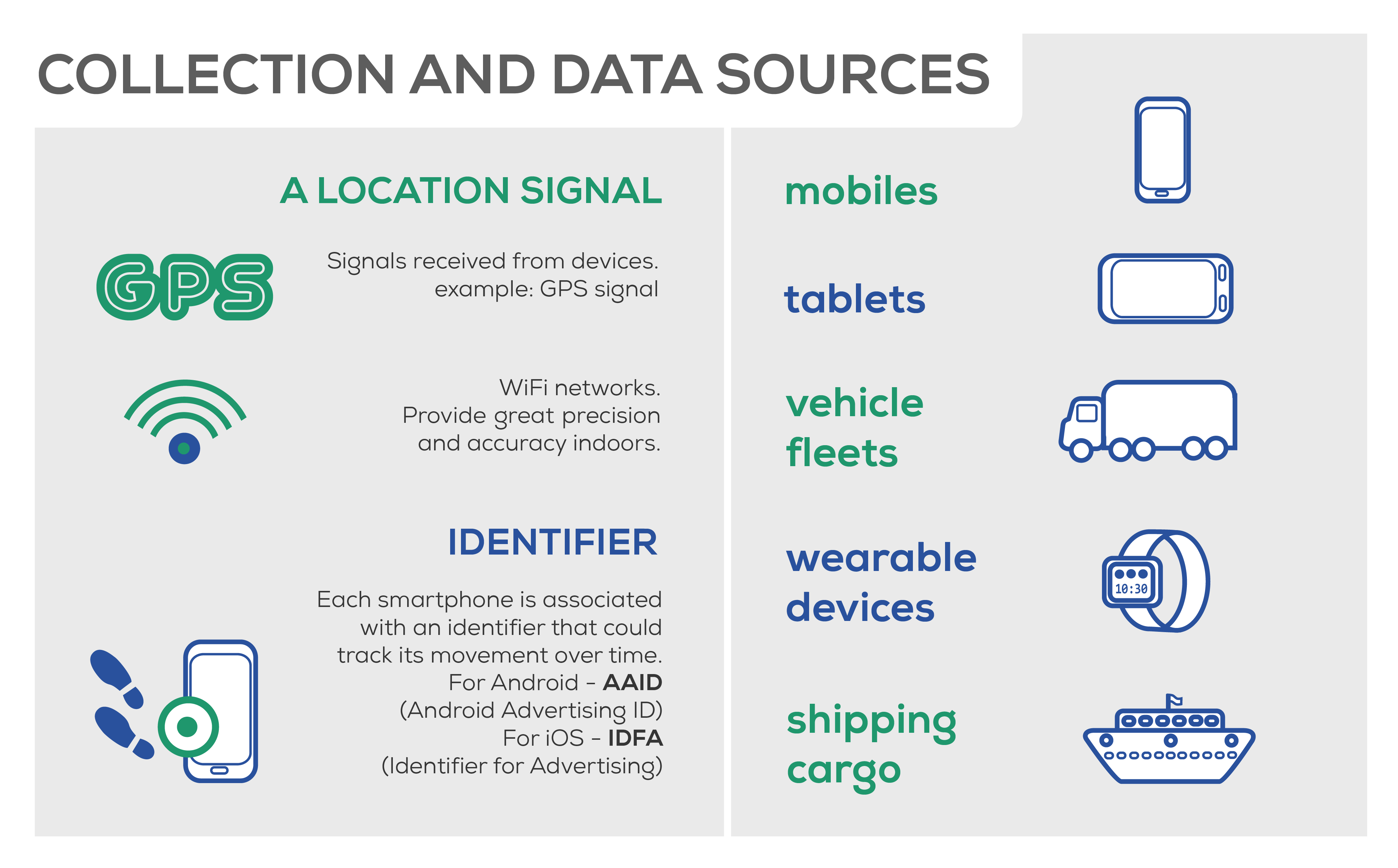
(Click image to enlarge)
Software development kit (SDK) - What is a location SDK?
Remember the SDK we mentioned above? It’s a set of software tools built into an app by its publishers. SDKs can monitor user behavior, transactions, app performance – and, importantly for us, location. SDK location data is offered by the majority of location analytics companies.
Some SDKs use the OS alone to provide a precise location for the device being used, but others optimize this with additional analytics. A location SDK requires the user to give permission for the app to access their location, which is done by the app’s API (application programming interface). This access can be constantly on in the background, like with weather apps or Apple’s ‘Find My Friends’, or just when the app is open, like a food delivery or taxi app.
SDKs can perform a wide range of functions, but this means that the data reliability varies from one SDK to the next. The most accurate SDKs can listen to multiple signals, for example GPS and Bluetooth from beacons, and combine these signals to generate the device’s location throughout the day within a metre of data accuracy.
Because SDKs are codes built into apps, the scale of the SDK location data they provide depends on how many devices have that app. Constant tracking of location requires a lot of the device’s battery power, which prompts many users to turn off the location capability. Only when a considerable number of devices have the app downloaded and location-tracking enabled can the geolocation SDK data be analysed for patterns and insights, otherwise the data can’t represent a sizeable enough chunk of the smartphone population.
Bidstream/ad open
To understand this source of location data, let’s have a quick look at how ads are traded online:
Digital ad inventory: Explained
Ads are traded online in three ways:
- Direct deals with the creator of the app, website or social network.
- Ad networks gather ad inventory according to certain categories, then sell the inventory to advertisers.
- Ad exchanges allow ad inventories to be traded in real-time as advertisers bid for them. This is the most common way of trading ads today, and is known as the ‘bidstream’.
The first two ad trading options don’t generate any location data. However, the ad exchange, or bidstream, does. When deciding whether to serve an ad on a device, advertisers consider the following device attributes (amongst others) before making a bid:
- URL
- Device type
- IP address
- Connectivity (WiFi, 3G, 4G)
- OS
- Timestamp
- and, fortunately for us, location!
All of this information is parcelled up in the ‘bid request’. So, device location data could be seen as a ‘by-product’ of real-time bidding (RTB), which we call bidstream data. Bidstream data is accessible to any company or organisation to a demand-side platform (DSP). This is both a blessing and a curse, because the data is out there waiting to be mined, but, of course, your competitors will likely have the same idea.
The scale of bidstream data is vast, and can be accessed and implemented immediately, because it’s collected programmatically by the IAB’s protocol ‘OpenRTB’ – millions of bid requests per second, in fact. OpenRTB is also responsible for policing how recent the data is. By looking at the data fetch timestamp, you can decide if it’s recent enough.
The main downside to bidstream? How unreliable it is.
Approximately 60% of ad requests contain some form of location information. Of these requests, less than 1/3 are accurate within a 50-100 meters of the specified location– Foursquare, Thinknear, Ubimo, xAD, Inc.
The problem is how the location in the bid request is derived. It could be GPS (a ‘Type One’ source, meaning it’s more accurate), but equally, the location could be based off user-input data or an IP address, which aren’t always accurate.
For example, you might be in London and search for restaurants in Paris on your smartphone, which could cause the bidstream data to incorrectly give your location as Paris based on your manual activity. This is where user behavior and intent don’t always correspond to their location. Similarly, IP addresses rotate every few months, making it difficult to use them to accurately track location over a longer period of time. So with bidstream collection, there’s the risk that your location intelligence data is inaccurate. There are also concerns that bidstream data could be fraudulent, or that publishers could give incorrect source information.
Telcos
We’ve looked at how cell towers can generate location data. Well, this data can be obtained directly from telecommunication companies (telcos). The same pros and cons apply to this source as to the cell tower triangulation method of collecting it – great for scale, but not always precise. The data available from telcos depends on the size of the telco in question. Some telcos are responsible for supplying signals to most of a country’s population - this allows you to access location intelligence at scale. In fact, the scale of the data offered by telcos makes them a hugely attractive location data source.
Publisher datasets
Location data can be collected by app publishers themselves. If the app has inbuilt location services (like searching for a taxi from one city to another, or the option to click ‘stores near me’) then this information can be converted into a device location. As with all user-input data, the data generated won’t be as accurate as data collected using signals, unless you can verify the method used by the publisher.
So let’s recap. The method? Mobile location data is collected by various signals which are received by your smartphone. The source? SDKs, bidstream, telcos, and publisher datasets.
We’ve looked at some of the pros and cons of each method and source – but how can we use this to ensure that the location data we use is of a high quality? Just like with the transmitters we discussed in part 1, the best way of ruling out error and getting the clearest picture possible is to consult multiple data sources, and compare data providers, products and datasets. Don’t put all of your eggs in one basket!
But before you invest in any source at all, it’s crucial to determine the quality of the data you’ll be provided with. So, our next step: data quality control.
Who is using location data?
Location data collection isn’t a new phenomenon – it’s the same basic information that’s collected whenever you enter where you live or work, so that marketing material can be sent to you. The insights provided by location intelligence is relied upon for a variety of use cases, from public planning and infrastructure, to fraud detection and location verification. What’s really getting people talking, however, is how mobile location data has transformed digital marketing and advertising.
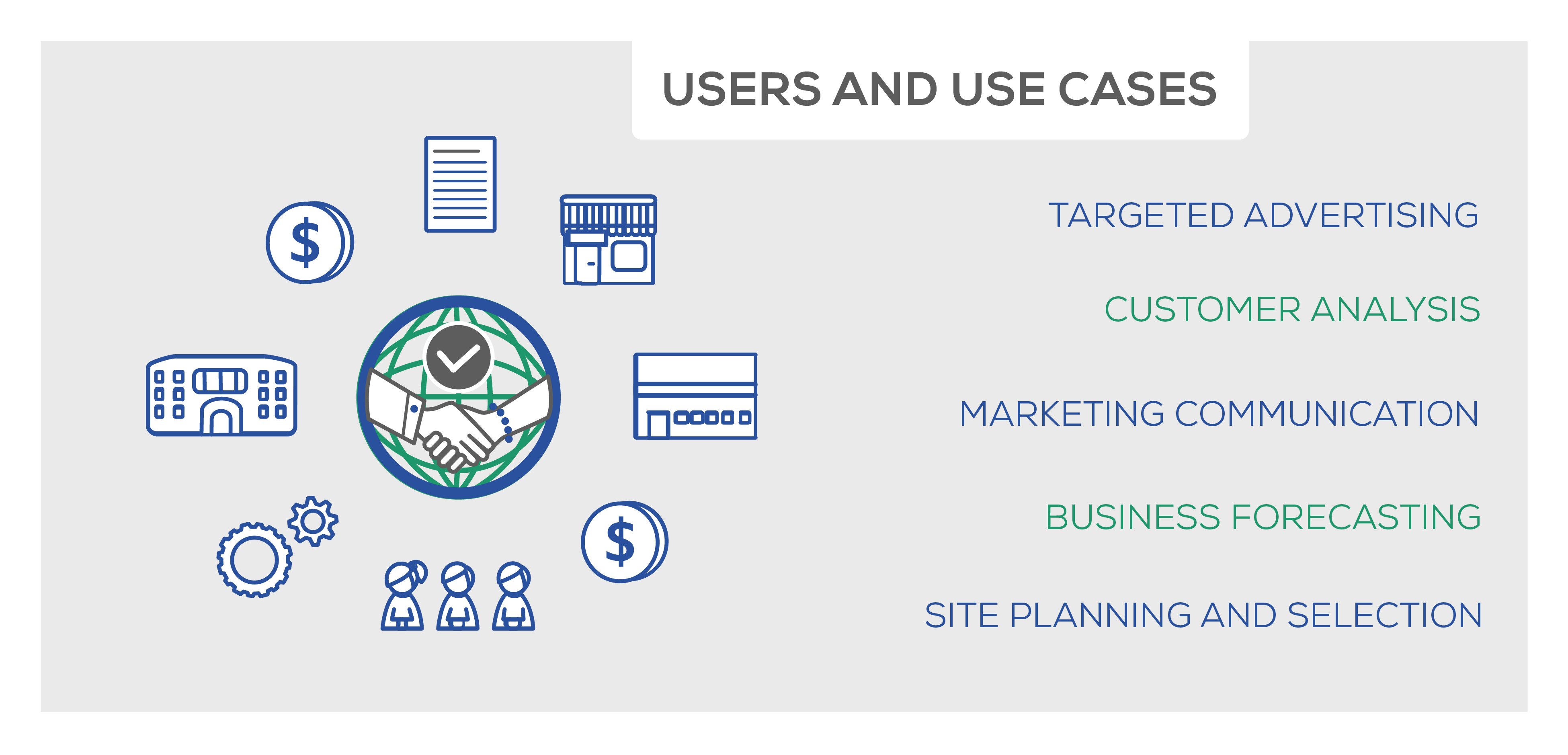
(Click image to enlarge)
Marketers - Location-based Marketing
As we know, how you market a product depends entirely on context. Knowing where your prospective customers come from and travel to increases the detail of your buyer persona dramatically. If your task is to market an athletic clothing brand, a lot of the market research you’d do is linked to location. Where does your buyer persona live – in the city centre or the suburbs? Where do they exercise – do they travel to a gym, or stay near their home? How much time do they spend there? Which brand competition would you face in this area? Would the average income of that location affect how you price the product? What are the opportunities for opening stores or running ad campaigns there? The answer to all of these questions about behavior, interests, intent, brand affinity lies in location intelligence, which is why so many marketers are choosing to buy store locations’ data. With a location dataset, you can roll out location-based targeting initiatives. Location-based mobile marketing allows marketers to drive up conversions and ROI, whilst gaining a clear insight into consumer behavior.
For the digital marketer specifically, understanding how prospective customers use their smartphones in an area is vital. If the gym-goer uses a fitness app, then in-app ads for athletic clothing are a good idea. If they go and buy a coffee on the journey home, you might spot an opportunity to collaborate with the coffee shop or brand, like offering a discounted coffee if they purchase yoga pants. With location-based marketing, the possibilities are endless – context-aware location data allows marketers to be as creative and innovative as they want to be, safe in the knowledge that their decisions are backed up by facts.
Advertisers - Location-based Advertising
The global location-based advertising market had a value of USD 62.35 billion in 2019 and this is only expected to keep growing. It is forecast to register a compound annual growth rate (CAGR) of 17.4% between the years 2020-2027. Location data has opened up countless new ways for advertisers to communicate with prospective customers. It allows them to create campaigns based on wherever the customers go and what they do there, not just where they live.
Knowing a customer’s visitation habits, you can determine which media platform is best suited to your campaign. If you can see that your buyer persona takes the bus to work and uses Facebook during the journey, it’s probably more effective to create in-app ads for your brand rather than physical billboards, which your customer won’t be paying attention to.
Location-based marketing companies also fine-tune their brand message based on location data. If you notice that your buyer persona frequently visits the cinema, not only could you place adverts there, but you could shape your campaign so that it’s in line with the latest blockbusters.
These location-based examples may sound far-fetched, but marketers and advertisers are having to create increasingly inspired solutions as both our physical and online world becomes more packed with content. All sorts of social and cultural factors come into play as a prospective customer makes their way down the sales funnel.
We’re used to hearing about data in a marketing and advertising context. But is location data only useful for businesses? Not at all – it can transform how supply chain managers control their stock, how finance analysts invest their money, even how governments are run. That’s the beauty of such a versatile data type:
Retailers
Retailers of all sizes are using store location data for retail analytics, including customer behavior, store visits and point of sale locations. Stores location data also allows brick and mortar store to benchmark their performance against competitor stores in the area. Visit data helps increase revenue by adjusting opening times, stock orders and staff numbers according to footfall and peak times, and by knowing which storefronts and layouts create interest and result in more purchases. What is being used here is known as data-driven forecasting. This is a technique being used more and more by businesses as a way of optimising their efficiency.
For example, location data can indicate to a retailer that footfall is highest in the lead up to Christmas. Retailers can then use this knowledge to increase their staff numbers and anticipate a surge in sales. Just as a business may use this location data to increase their staff numbers at busier times, they may also cut staff numbers at times they know are less busy in order to ensure that they are not overstaffed and, therefore, less efficient. Retailers can make huge savings just by applying the knowledge gained from the purchase of location data to their operations.
Hotels and Malls
With larger buildings, you need to know where visitors spend the most time and how they get there. If you oversee a hotel’s operations and notice that guests spend a long time waiting in the lobby, this raises concerns about how likely they are to then visit your restaurant, so you would make changes to how the reception is managed. For a mall, you could rearrange the layout of the building to subtly encourage customers and guests to venture further inside. If your most popular attraction according to foot traffic measurement is the food court, you’d consider putting this at the centre of the mall, or improve signage to other stores and attractions.
Finance Analysts and Financiers
Location data is a vital tool for finance analysts. It helps them detect criminal activity and guard users by adding a robust security layer. Financers can use location data to predict earnings in line with an area’s inflation level, KPIs, and the number of customers based on previous footfall. All this helps them make the best investment decisions.
Real Estate Investors
Real estate investors also use location data to understand how busy specific regions are, how well local businesses are performing, and what the general demographic in that region is. Increasingly, real estate analytics use POI data in property valuation to determine how desirable the property’s location is.
Government
Governments use location data to understand how different cities and towns function independently and are connected to one another. It helps them craft better public infrastructure, based on POIs and traffic analysis. For example, location data can tell them which roads cyclists use most often, so that they can plan new cycle lanes, or where traffic is most congested, so that bigger cities can introduce low emission zones.
As more people are making the switch to electric vehicles local councils are turning to location data to inform the placement of charging points across cities. From September 2019 to February 2020, Oxford City Council relied heavily on location data collected across the city to select a road to trial the instalment of six prototype charging points. The data allowed the council to take the city’s narrow streets and pavements into account. Smart motorways offer another relevant example of governments’ use of location data. As of 2020, smart motorways covered more than 400 miles of England. Smart motorways use data collected from cameras to detect how congested a stretch of motorway is, allowing the hard shoulder to be used as an extra lane or variable speed limits to be implemented in order to limit congestion.
Shipping and Haulage
GPS location data is vital for asset tracking - in other words, ensuring that goods and services are transported safely from A to B. Similarly, satellite location data and real-time traffic reports can help logistics and distribution teams plan the most efficient routes. Not only is it becoming more commonplace for customers to track their online orders to ensure their parcels arrive safely, but many companies are now offering customers the option to decline a delivery time in order to ensure they are at home when the package arrives.
For example, DPD now informs their customers of the time slot in which a parcel is scheduled to be delivered and gives them the option to redirect their parcel or request for a delivery on the following day. This allows DPD to increase their delivery service’s efficiency, reducing the number of undelivered parcels. Similarly, takeaway services such as JustEat utilise location data for route optimisation. By collecting the addresses of customers and the restaurants from which they are ordering, takeaway services can allocate the delivery driver in the most opportune location to ensure a fast delivery to the customer.
Travel, Tourism and Hospitality
Travel companies and hospitality services such as hotels rely on location data to gain an insight into customers’ movements and travel preferences. By engaging with this data, it is possible to target advertisements in a way that is likely to attract regular custom. One thing the Coronavirus pandemic has made clear is the necessity for companies to attract loyal customers in order to ensure not only their success, but also their survival. By asking themselves where customers travelled before and during the pandemic and how cautious they feel in regards to travel, travel companies are able to tailor advertisements to their customers. Not only are they able to gauge what sort of trips are the most desired but they are also able to reinforce their marketing with the assurance that health guidelines are being adhered to, with strict sanitation measures in place.
So location data isn’t just an asset for marketers. It has the potential to improve where we live, and how. This brings us to part 5: how online data is used in the offline world.
Main Use Cases
There are countless marketing and advertising strategies involving geographic targeting. They all boil down to tracking mobility, analyzing patterns, and targeting the areas which will boost your ROI and improve your understanding of your customers for segmentation.
(Click image to enlarge)
You can buy cell phone location data for the following use cases:
Footfall Traffic Analysis
This could be seen as the ‘first step’ towards utilizing your location data effectively. The data uses a footfall tracker to show you trends in footfall, such as which locations are popular, and whether this varies over time. From this, you can create location visualization tools, like ‘heat maps’ which estimate where the best locations for ad campaigns are. You can create additional heat maps based on the peak day or time of day for footfall, and maximise the exposure of your campaign. Good location data will distinguish between employees and passers-by by considering the ‘dwell time’ of the device, so your understanding of footfall isn’t skewed.
Attribution Analysis
This comes after footfall tracking and analysis. By knowing how many people visit a location and what the peak visitation times are, you can direct your campaigns on this basis. If you see that footfall increases after you’ve trialled an in-app ad or promotion, then you can roll this campaign out further because the footfall indicates a good ROI. Attributing footfall is increasingly relevant for businesses which offer both in-store and online purchases. If an ad campaign is generating interest, then why are you selling more of the same products online than in person? If you can track the customer’s physical journey as well as their online interactions, you can see what’s preventing them from making in-store purchases, and alter your storefront, billboards and store layout accordingly.
Original Destination Study (O-D)
An O-D Study can show you long-term patterns about how people travel. It relies on GPS, and is also used in road and infrastructure planning. Knowing where people travel to and from, you can place billboards and visuals along popular commuter routes and where the flow of traffic is most heavy.
Out-of-Home (OOH) Analysis
OOH refers to any media you’ll see in the public sphere, including malls, stores, train stations and airports. The media can be billboards, signs, TVs and posters. Being able to analyse how devices move in relation to the OOH media they’re exposed to can allow you to see which media forms are most successful and where the optimum location for them is. This can be done by looking at which devices that saw the media ended up being used to make an online purchase. The analysis might show you that customers respond best to digital billboards over traditional, paper billboards. From there, you could decide that Digital OOH (DOOH) is more cost-effective, because the movement on-screen attracts attention, even though the cost of installation is higher.
POI Mapping
Location data can be used alongside a POI database to create POI maps. POI mapping is the process of plotting important or popular locations on a map to see their geographical proximity to one another. POI and location intelligence mapping is used in ad placement and retail site planning to see where ads and stores will attract footfall, or face competition from other POIs.
In-flight Campaigns
Here, location-based marketing uses footfall analysis heatmaps and DOOH analytics in conjunction. A huge benefit of using digital ads over traditional ones is that you can adjust them as you go along, or ‘in-flight’. These adjustments can be made based on the results of A/B testing to see which approach generates more lift. Although making these tweaks can require more time and money, from a ROI perspective, it’s a better alternative then having to go and physically replace billboards and print new ones!
Geofencing
Geofencing allows you to create a virtual ‘fence’ around a geographic area. Normally, you’d pick this area because your heatmaps are showing you that there’s a high concentration of foot traffic there, and the people who visit there match your target demographic. You can use lat/long coordinates or beacons to create a boundary which can take any shape you need. When a device crosses the geofence, a response is triggered programmatically in real-time. Then, you can deliver location-specific ads, push notifications or even photo geo-filters (on apps like Snapchat) to the device.
Geotargeting
More sophisticated geofences can tailor the ads they send so that they’re only sent to devices whose users match predetermined criteria. This is called geotargeting, and it works by combining real-time location data with other data about customer attributes – their behaviour, demographic, interests etc. – making the campaign you create better suited to your audience.
Geo-conquests
Businesses can also use their store location database to set up geofences around zones where they face competition and push ads and promotions in that area. In 2020, Whole Foods turned to geo-conquesting to increase their sales. Their aim was to improve post-click conversion rates on their mobile ads. Post-click conversion rates indicate the number of people who click on a paid-for advertisement and proceed to engage in some way, whether that be a sign up or a purchase. Whole Foods placed geofences around its stores, whilst also placing geofences around competitors’ stores. When a customer entered these areas they were targeted with ads and discounts for Whole Foods, aiming to deter them from the competitors’ stores and attract them to Whole Foods. It’s safe to say this was a successful example of geoconquesting, with the campaign yielding Whole Foods a post-click conversion rate of 4.69%, more than three times the national average of 1.43%.
All of these strategies become more effective when supplemented with audience and POI data , so you can understand which locations are popular with which types of people and create appropriate segments. Let’s say you notice that an inner-city gym is a POI. This information alone isn’t helpful – what if you’re a desserts company? Just because a location itself is attractive in terms of footfall, this doesn’t necessarily mean it’s a good location to centre an ad campaign around. Supplementing your geolocation dataset with other data types can give you the strongest chance of creating a successful campaign. A good cell location data supplier offers context-aware location datasets, which take into account consumer data alongside the raw location databases and APIs.
Which delivery formats can Location Data be delivered in?
- S3 Bucket - This is a public cloud storage resource which is part of Amazon Web Services’ (AWS) Simple Storage Service (S3). Essentially, buckets are places to store files (or ‘objects’, as Amazon calls them). They can be accessed using URLs so must have globally unique names.
- SFTP - Secure File Transfer Protocol is a file protocol that allows you to transfer large files online. This ensures the security of files when being transferred. When certain data protection standards need to be met (such as GDPR mentioned previously), businesses can rely on SFTP to ensure these standards are satisfied.
- REST API - REST stands for Representational State Transfer. REST can be seen as a set of rules for communication between programs. The information abstracted using REST is called a resource. This could be a document or image, for example. REST APIs function by receiving requests for a resource and returning all relevant information about the resource in a format easily understood by the client.
That’s a lot of things to ask your data vendor. We’ve put together a handy list of the most important things to ask to ensure you’re buying the most robust dataset:
- What is the source of the data – first, second or third-party?
- How do you verify your data?
- Do you filter out poor-quality or irrelevant data?
- How do you collect the data (GPS, WiFi, beacons etc)?
- What is the scale of your dataset?
- Can you prove your data is GDPR and CCPA compliant?
- Do you offer a location data sample?
Considering location-based marketing or advertising? Here’s a quick overview on how location data is typically priced, and where you can buy location databases.
Frequently Asked Questions
Where can I buy Location Data?
Data providers and vendors listed on Datarade sell Location Data products and samples. Popular Location Data products and datasets available on our platform are Factori Raw Location Data | Global mobile location data (1 year history) by Factori, Irys | Location Data Solutions | Worldwide Global | Real-Time & Historical Mobile Data & Connected Device Location Data by Irys, and Area Visitors – analyze global foot traffic trends for geographic areas via API or batch data delivery by Gravy Analytics by Unacast.
How can I get Location Data?
You can get Location Data via a range of delivery methods - the right one for you depends on your use case. For example, historical Location Data is usually available to download in bulk and delivered using an S3 bucket. On the other hand, if your use case is time-critical, you can buy real-time Location Data APIs, feeds and streams to download the most up-to-date intelligence.
What are similar data types to Location Data?
Location Data is similar to Map Data, Satellite Data, Foot Traffic Data, Point of Interest (POI) Data, and Mobile Location Data. These data categories are commonly used for Location-based Marketing and Location-based Marketing.
What are the most common use cases for Location Data?
The top use cases for Location Data are Location-based Marketing, Location-based Marketing, and Location-based Marketing.